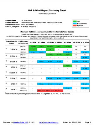
Our reports cover a date range specified by you, spanning up to 7 years, ensuring a thorough analysis of NOAA/NWS weather events.

With the mission to protect property, and enhance the United States’ economy, NOAA’s National Weather Service is the sole official voice of the U.S. government for issuing warning during life-threatening weather situations.

Focused on delivering precise data, our reports include:
Covering a 5-mile radius, combining eyewitness accounts (SED) and radar data (SWDI).
Covering a 10-mile radius for thunderstorm winds (SED) and tornadoes (SED), with eyewitness estimated and measured wind data.
Detailed data within a 5-mile radius, sourced from radar (SWDI), shows high tornadic energy in the atmosphere.
Utilizing measured wind data (ASOS) from the closest airport and a second airport if within a 20-mile radius; data includes winds from hurricanes.
Documented +70-mph winds (SED) in the NWS Zone.

All information is sourced from the National Oceanic and Atmospheric Administration (NOAA) / National Weather Service (NWS). This includes the Severe Events Database (SED) for hail, thunderstorm winds, high winds, and tornadoes, the Automatic Surface Operating System (ASOS) for airport-measured winds, and the NEXRAD Radar for hail and tornadic events.

Each report’s NWS data continuously undergoes the procedures of the Federal Quality Control Standards (NWS Directive 10-1605).

WeatherStrike has no disclaimers about the accuracy or completeness of the NWS Products used in its’ reports, except possible omissions of data due to the collection procedures of the NWS.
The primary objective of our reports is to help you pinpoint the exact dates of significant NWS weather events, such as large hail or high winds at or near your site-specific location. This documented information is crucial in various scenarios, such as:


Leverage over 20 years of NOAA/NWS meteorological data analysis expertise and experience.

Whether investigating a recent storm or researching historical weather patterns, our reports are designed to provide the site-specific data you need.

Reports are structured for clarity and ease of interpretation, making your analysis straightforward.
